Troop 849
Manhattan Beach, CA
Boy Scouts of America
Home
New Members
Calendar
Scout Pages
Advancement
Special Awards
Backpacking
Weekend
Advanced
Longterm
Last Updated:
January 13, 2017
| General | Trail Saver | Peak Bagger | Mini-Peak Bagger | 7 League Boot | Night Camper | Backpacker | ||
|
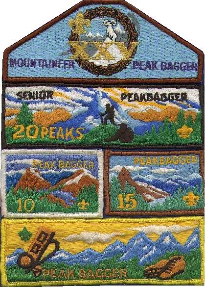
Peak Bagger AwardsClimb the mountains and get their good tidings - John Muir |
Introduction
The Peak Bagger Program is designed to stimulate a greater appreciation of the alpine wilderness, while experiencing the beauty, peace and majesty of the mountains. Each peak has been carefully selected so that a variety of locations may be reached on backpacking treks, without the use of mountaineering skills. The Peak Bagger Award is a cumulative award series that recognizes High Adventure achievement. While few people are privileged to make first ascents, it is possible to experience the thrill of standing on the windswept summit and carry the memory forever. Look upon the lush, flower-starred greenness of alpine meadows, the harsh purity of rocky landscapes above timberline, or the almost supernatural touch of alpenglow upon the peaks, and you will surely join the growing ranks of those who love the mountains.
The Peak Bagger Program is graduated to fill the needs of all, from the relative novice to the experienced mountaineer. The Basic Award is easy enough for the newcomer who is ready and willing to put forth that extra effort. But, even the Basic Award is more than just climbing five mountains. It is also a learning experience, that is, learning the effects of high altitude, the need for carrying the ten essentials, and the rewards and sense of achievement from standing on a mountain top. There is no time limit for earning these awards. Happy climbing, and remember -
Nothing of worth or weight can be achieved with half a mind, with a faint heart, or with lame endeavor - Barrow
Awards
| Award | Requirements |
|---|---|
| Basic (5) | Climb five peaks, consisting of no more than two from any Group (A-F) |
| 10-Peak | Climb five additional peaks consisting of one each from Groups A, B, C, and two from Group D |
| 15-Peak | Climb five additional peaks consisting of two from Group C, two from Group D, and one from Group E |
| Senior (20) | Climb five additional peaks consisting of two from Group D and three from Group E |
| Mountaineer (25) | Climb five additional peaks consisting of two from Group E and three from Group F |
Substitutions
Once the Basic Peak Bagger has been earned, any peak may be substituted for a lower peak as follows:
- Group F may be substituted for Groups C, D, or E
- Group E may be substituted for Groups C or D
- Group D may be substituted for Group C
- Group C may be substituted for Groups A or B
- Group B may be substituted for Group A
Group A Peaks - Southern California
| Name | Elev. | Topo map | Rating | Trailhead/Approach |
|---|---|---|---|---|
| Alto Diablo (1) | 10500 | Big Bear Lake | M2 | Poopout Hill; Forsee Creek |
| Charlton | 10806 | San Gorgonio Mtn | M2 | Poopout Hill |
| Grinell | 10284 | Moonridge | M2 | Aspen Grove (4); Poopout Hill |
| Lake Peak | 10161 | San Gorgonio Mtn | M2 | Aspen Grove (4); Poopout Hill |
| Little Charlton | 10696 | San Gorgonio Mtn | M2 | Fallsvale |
| Peak 9971 (2) | 9971 | San Gorgonio Mtn | M2 | Aspen Grove (4); Poopout Hill |
| Peak 10067 (2) | 10067 | San Gorgonio Mtn | M2 | Aspen Grove (4); Poopout Hill |
| Red Tahquitz | 8720 | San Jacinto Peak | M2 | Humber Park/Saddle Jct |
| South Peak | 7840 | Idyllwild | M2 | Humber Park/Saddle Jct |
| Tahquitz | 8846 | San Jacinto Peak | M1 | Humber Park/Saddle Jct |
| Zahniser (3) | 10156 | San Gorgonio Mtn | M2 | Poopout Hill; Dry Lake |
- East of Shields Flat (approximately 0.6 mile).
- ESE of Lake Peak.
- North of Mine Shaft Saddle.
- Fish Creek Meadow trailhead does not meet minimum hiking hours for Peakbagger trip.
Group A Peaks - Sierra
| Name | Elev. | Topo map | Rating | Trailhead/Approach |
|---|---|---|---|---|
| Blackrock Mtn | 9635 | Casa Vieja Meadows | M2 | Kennedy Meadows |
| Kaiser Peak | 10320 | Kaiser Peak | H1 | Lakeshore |
| Mono Dome | 10614 | Mt. Dana | M2 | Log Cabin Mine |
| Peak 9870 (1) | 9870 | Mt. Silliman | M2 | Horse Corral Creek |
| Shell Mountain | 9594 | Muir Grove | M2 | Stoney Creek Campground |
- Between Pond Meadow and Mitchell Peak.
Group A Peaks - Philmont
| Name | Elev. |
|---|---|
| Bear Mtn. | 10663 |
| Big Red | 11024 |
| Black Mtn. | 10892 |
| Bonita Peak | 10676 |
| Mt. Phillips | 11711 |
| Trail Peak | 10242 |
Group B Peaks - Southern California
| Name | Elev. | Topo map | Rating | Trailhead/Approach |
|---|---|---|---|---|
| Anderson Peak | 10840 | Big Bear Lake | M1 | Barton Flats; Forsee Creek |
| Dobbs Peak | 10459 | San Gorgonio Mtn | M2 | Poopout Hill |
| E. San Bernardino | 10691 | Big Bear Lake | M1 | Barton Flats; Forsee Creek |
| Jepson Peak | 11205 | San Gorgonio Mtn | M2 | Poopout Hill; Vivian Creek |
| Mt. San Gorgonio | 11499 | San Gorgonio Mtn | M1 | Poopout Hill; Vivian Creek |
| Shields Peak | 10680 | Big Bear Lake | M1 | Barton Flats; Forsee Creek |
| Sugarloaf Mtn | 9952 | Moonridge | M1 | Hwy. 38; Wildhorse Creek |
Group B Peaks - Sierra
| Name | Elev. | Topo map | Rating | Trailhead/Approach |
|---|---|---|---|---|
| Corral Mtn | 9680 | Courtwright Reservoir | M2 | Courtwright Reservoir |
| Hoffman Mtn | 9622 | Rough Spur | M2 | Wishon Reservoir |
| Tioga Peak | 11513 | Mt. Dana | M2 | Warren Fork; Saddlebag Lake |
| Twin Peaks | 10485 | Mt. Silliman | H2 | Lodgepole |
Group B Peaks - Philmont
| Name | Elev. |
|---|---|
| Baldy Mtn | 12441 |
| Cimarroncito | 10468 |
Group C Peaks - Southern California
| Name | Elev. | Topo map | Rating | Trailhead/Approach |
|---|---|---|---|---|
| Big Horn (1) | 10997 | San Gorgonio Mtn. | M2 | Poopout Hill; Vivian Creek |
| Folly Peak | 10480 | San Jacinto Peak | M2 | Round Vly; Little Round Vly |
| Jean Peak | 10670 | San Jacinto Peak | M2 | Round Vly; Little Round Vly |
| Mt. San Jacinto | 10804 | San Jacinto Peak | M1 | Round Vly; Little Round Vly |
| San Bernardino | 10649 | Big Bear Lake | M1 | Angelus Oaks |
- SSE of Mt. San Gorgonio, about 0.7 miles.
Group C Peaks - Sierra
| Name | Elev. | Topo map | Rating | Trailhead/Approach |
|---|---|---|---|---|
| Alta Peak | 11204 | Lodgepole | M2 | Wolverton; Giant Forest |
| Blacktop Peak | 12668 | Koip Peak | H2 | Crest Creek; Alger Lakes |
| Brown Mt. | 9958 | Templeton Mountain | L2 | Sage Flats; Cottonwood |
| Castle Peak | 10677 | Tehipite Dome | M2 | Wishon Reservoir; Chain Lakes |
| Cirque Peak | 12900 | Cirque Peak | H2 | New Army Pass (1) |
| Coyote Peak | 10892 | Kern Lake | L2 | Mineral King/Coyote Lake |
| Deer Mt. | 9410 | Haiwee Pass | M2 | Kennedy Mdw |
| Fleming Mtn | 10796 | Mt. Henry | L2 | Courtwright Reservoir |
| Goode, Mt. | 13092 | North Palisade | H2 | South Lake |
| Gould, Mt. | 13005 | Mt. Clarence King | M2 | Onion Valley |
| Iron Mtn | 11149 | Cattle Mtn | H1 L2 |
Ashley Lake Iron Lake |
| Julius Caesar, Mt. | 13196 | Mt. Hilgard | H2 | Pine Creek |
| Kearsarge Peak | 12598 | Kearsarge Peak | M2 | Onion Valley |
| Kern Peak | 11510 | Kern Peak | S2 | Cottonwood/Ramshaw Mdw |
| Kettle Peak | 10041 | Mt. Silliman | H2 | Lodgepole |
| Lamark, Mt. | 13417 | Mt. Darwin | H2 | North Lake; Lake Sabrina |
| LeeVining Peak | 11691 | Mt. Dana | M2 | Log Cabin Mine |
| Loper Peak | 10059 | Courtwright Reservoir | M2 | Wishon Reservoir |
| Maggie Mt. | 10042 | Quinn Peak | L2 | Maggie Lakes |
| Mitchell Peak | 10365 | Mt. Silliman | M1 | Horse Corral Mdw; Lodgepole |
| Monache Mtn | 9410 | Monache Mtn | M2 | Kennedy Mdw |
| Morgan, Mt. | 13748 | Mt. Morgan | M2 | Rock Creek |
| Muah Mtn | 11016 | Bartlett | M2 | Cottonwood; Mulkey Mdw |
| Nelson Mtn | 10220 | Nelson Mtn | M2 | Dinkey Creek Road |
| Spanish Mtn | 10051 | Rough Spur | H2 | Wishon Reservoir; Spanish Lakes |
| Starr, Mt. | 12870 | Mt. Abbott | M2 | Rock Creek |
| Templeton Mtn | 9932 | Templeton Mtn | S2 | Cottonwood |
| Three Sisters | 10619 | Dogtooth Peak | L2 | Dinkey Creek Road |
| Vandever Mtn | 11947 | Mineral King | M2 | Mineral King |
| Warren, Mt. | 12327 | Mt. Dana | H2 | Warren Fork; Log Cabin Mine |
| White Chief Peak | 11020 | Mineral King | M2 | Mineral King |
- Cirque is a D peak when appoached from Chicken Spring Lake.
Group D Peaks - Sierra
| Name | Elev. | Topo map | Rating | Trailhead/Approach |
|---|---|---|---|---|
| Agassiz, Mt. | 13891 | North Palisade | H2 | South Lake/Bishop Pass |
| Angora Mtn | 10202 | Kern Lake | L2 | Mineral King |
| Bago, Mt. | 11869 | Mt. Clarence King | L2 | Charlotte Lake |
| Banner Peak | 12945 | Mt. Ritter | S3 | Thousand Island Lake |
| Basin Mtn | 13240 | Mt. Tom | H2 | Horton Creek |
| Blackcap Mtn | 11559 | Blackcap Mtn | L2 | Wishon Reservoir; Kings River |
| Cirque Peak | 12900 | Cirque Peak | H2 | Chicken Spring Lake(1) |
| Dade, Mt. | 13600 | Mt. Abbott | H2 | Rock Creek/Treasure Lakes |
| Dana, Mt. | 13053 | Mt. Dana | H2 | Tioga Pass |
| Davis, Mt. | 12311 | Mt. Ritter | S2 | Thousand Island Lake |
| Florence Peak | 12432 | Mineral King | H2 | Mineral King/Franklin Pass |
| Gayley, Mt. | 13510 | Split Mtn | H3 | So. Fork Big Pine Creek |
| Graveyard Peak | 11494 | Graveyard Peak | H2 | Edison Lake/Graveyard Lakes |
| Guyot, Mt. | 12300 | Mt. Whitney | L2 | Cottonwood/Guyot Flat |
| Hitchcock, Mt. | 13184 | Mt. Whitney | L2 | Crabtree Lakes |
| Hutchings, Mt. | 10785 | The Sphinx | S2 | Kings Canyon |
| Johnson Peak | 11371 | Johnson Peak | L2 | Mineral King |
| Kennedy Mtn | 11433 | Slide Bluffs | S2 | Kings Canyon |
| Langley, Mt. | 14042 | Mt. Langley | H2 | Cottonwood/ New Army Pass |
| Lone Pine Peak | 12944 | Mt. Langley | H2 | Whitney Portal/Meysan Lake |
| Mallory, Mt. | 13850 | Mt. Whitney | H2 | Whitney Portal/Meysan Lake |
| Muir, Mt. | 14015 | Mt. Whitney | L3 | Crabtree Mdw |
| Red Mtn | 11951 | Mt. Henry | L2 | Courtwright Reservoir/Flemming Creek |
| Sawtooth Peak | 12343 | Mineral King | S2 | Mineral King/Sawtooth Pass |
| Silver Peak | 11878 | Sharktooth Peak | L2 | Edison Lake |
| Tom, Mt. | 13652 | Mt. Tom | H2 | Horton Creek |
| Tyndall, Mt. | 14018 | Mt. Williamson | S2 | Symmes Creek/Shepherd Pass |
| Whitney, Mt. | 14495 | Mt. Whitney | L1 S1 |
Crabtree Mdw Whitney Portal |
- Cirque is a C peak when approached from New Army Pass.
Group E Peaks - Sierra
| Name | Elev. | Topo map | Rating | Trailhead/Approach |
|---|---|---|---|---|
| Arrow Peak | 12958 | Mt. Pinchot | L2 | Bench Lake |
| Baldwin, Mt. | 12614 | Convict Lake | H2 | Lake Dorothy; Mildred Lake |
| Barnard, Mt. | 13990 | Mt. Williamson | L2 | Wallace Lakes |
| Black Giant | 13330 | Mt. Goddard | L2 | Muir Pass |
| Bradley, Mt. | 13289 | Mt. Williamson | L2 | Center Basin |
| Crocker, Mt. | 12457 | Mt. Abbott | S2 | McGee Creek; Rock Creek |
| Donohue Peak | 12023 | Koip Peak | S2 | June Lake |
| Eagle Scout Peak | 12040 | Triple Divide Peak | L2 | Crescent Mdw; Kaweah Gap |
| Electra Peak | 12442 | Mt. Lyell | L2 | Twin Lakes |
| Emerson, Mt. | 13225 | Mt. Darwin | H2 | North Lake/Piute Pass |
| Fiske, Mt. | 13524 | Mt. Darwin | L2 | Helen Lake; Sapphire Lake |
| Florence, Mt. | 12561 | Mt. Lyell | S2 | Yosemite Valley |
| Foerster Peak | 12058 | Mt. Lyell | L2 | Blue Lake |
| Gabb, Mt. | 13711 | Mt. Abbott | L2 | Lake Italy |
| Henry, Mt. | 12196 | Blackcap Mtn | S2 | Courtwright Reservoir |
| Hilgard, Mt. | 13361 | Mt. Elgard | L2 | Lake Italy |
| Hopkins, Mt. | 12302 | Mt. Abbott | S2 | Rock Creek |
| Huntington, Mt. | 12405 | Mt. Abbott | H2 L2 |
Rock Creek Pioneer Lake |
| Marion Peak | 12719 | Marion Peak | L2 | Marion Lake |
| Merced Peak | 11726 | Merced Peak | S2 | Yosemite Valley |
| Midway Mtn | 13666 | Mt. Brewer | L3 | Milestone Creek; Colby Lakes |
| Morrison, Mt. | 12268 | Convict Lake | H2 | Convict Lake |
| Pinchot, Mt. | 13495 | Mt. Pinchot | L3 | Pinchot Pass |
| Red Slate Mtn | 13163 | Convict Lake | S2 | McGee Creek |
| Rixford, Mt. | 12890 | Mt. Clarence King | S2 | Onion Valley |
| Sill, Mt. | 14162 | North Palisade | L3 | Palisade Basin |
| Silliman, Mt. | 11188 | Mt. Silliman | S2 | Lodgepole/Twin Lakes |
| Stanford, Mt. | 12851 | Mt. Abbott | S2 | McGee Creek; Rock Creek |
| Striped Mtn | 13189 | Mt. Pinchot | L2 | Taboose Pass |
| Triple Divide Peak | 12634 | Triple Divide Peak | L3 | Tamarack Lake; Nine Lake Basin |
| Woodworth, Mt. | 12219 | North Palisade | L2 | Middle Fork Kings River |
Group F Peaks - Sierra
| Name | Elev. | Topo map | Rating | Trailhead/Approach |
|---|---|---|---|---|
| Brewer, Mt. | 13570 | Mt. Brewer | S2 | Cedar Grove |
| Conness, Mt. | 12590 | Tioga Pass | S3 H3 |
Young Lakes Saddlebag Lake |
| Goddard, Mt. | 13568 | Mt. Goddard | L2 | Wanda Lake |
| Kaweah, Mt. | 13802 | Mt. Kaweah | L2 | Big Arroyo |
| Lyell, Mt. | 13114 | Mt. Lyell | L2 | Tuolumne Mdw |
| Maclure, Mt. | 12988 | Mt. Lyell | S3 | Tuolumne Mdw |
| Matterhorn Peak | 12264 | Matterhorn Peak | H2 | Twin Lakes |
| Olancha Peak | 12123 | Olancha Peak | H2 L2 |
Sage Flats Cottonwood |
| Ritter, Mt. | 13157 | Mt. Ritter | S3 | 1000 Island Lake |
| Split Mtn | 14058 | Split Mtn | S3 L2 |
Red Mtn Creek Upper Basin |
| University Peak | 13632 | Mt. Williamson | S2 L2 |
Onion Valley Center Basin |
| Williamson, Mt. | 14375 | Mt. Williamson | S2 | George Creek |
Rating System
| Approach rating: | M | Easy to moderate, two-day trip |
| H | Strenuous, two-day trip | |
| S | Moderate to strenuous, three-day trip | |
| L | Normally climbed as part of a week-long hike |
| Climb rating: | 1 | Trail leads all the way to the summit. Almost any footgear could be used, but boots are recommended for more comforatble hiking. |
| 2 | The final ascent has no maintained trail; however, a "climber's route" may sometimes be followed. The terrain is rougher and proper footgear, such as lug-soled boots with good traction, are strongly recommended. Hands may occasionally be used for balance in climbing. | |
| 3 | Handholds and footholds are used; lug sole boots are required. Exposure is such that some persons may wish to be belayed at times, so a rope, and knowledge of its use, should be taken. |
The Fine Print
Consult the latest copy of Hike Aid 16, "Peak Bagging: Program and Awards" for a current list of peaks and the complete requirements.
All requirements are as of January 2017
©2017 Boy Scout Troop 849, Manhattan Beach, CA. http://troop849.org/